
Quiet night on the coast after Boelo, but Keswick Campsite's still got a flood warning on Coastal flood warnings stay lifted after a quiet night, but Keswick Campsite is still on a flood warning
Marra Mode is how your mate would tell you down the pub over a pint. Switch it off for the straight version.
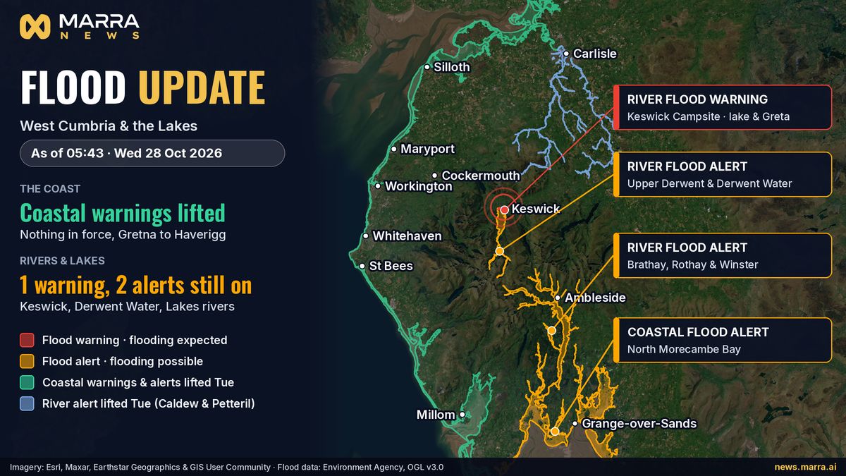
Nowt new overnight. The Environment Agency didn't put any fresh flood warnings out for Cumberland, and the coast's still clear from Gretna to Haverigg. Keswick Campsite's still on a warning though, and there are alerts on the Derwent, the Lakes rivers and Morecambe Bay. Right as of 05:43 on Wednesday 28 October.
This one's for anybody living by or driving along the coast, the Derwent or the Lakes, and anybody wondering if Boelo's finally done with us.
Updated at 05:43 on Wednesday 28 October 2026, straight from the Environment Agency's live flood data. Times are GMT.
Good news: it was a quiet night. The Environment Agency didn't put out any new flood warnings or alerts for Cumberland overnight, and none of the coastal ones came back on. Every coastal warning and alert from Gretna to Haverigg, plus Barrow and the Duddon estuary, came off on Tuesday. The ones for Maryport, Flimby, Workington and Whitehaven went between 07:43 and 08:02, and the last of the coastal lot went between 15:32 and 15:37. We had a good look round at 05:45 and there's nothing from Cumbria Police, the fire service or Cumberland Council about fresh flooding overnight.
Here's what's still on at 05:43. It's all rivers and lakes, apart from the last one:
Flood warning, so flooding's expected: Keswick Campsite, from Derwent Water and the River Greta. The Agency says the rivers and the lake are still high.
Flood alert, so flooding's possible: the Upper Derwent, Stonethwaite Beck and Derwent Water. It's low land and roads from Seathwaite down to the lake you want to watch.
Flood alert: the Brathay, Rothay and Winster rivers, from Grasmere right down to Grange-over-Sands.
Coastal flood alert: North Morecambe Bay, from Roosebeck to Carnforth. That was for the high tide between 21:45 last night and 01:45 this morning, and it was still showing at 05:43.
The Agency says it'll update the Keswick and Lakes ones by 9am and Morecambe Bay by 10am. The alert for the Caldew and Petteril round Carlisle came off at 07:02 on Tuesday.
The river gauges tell the story. The Greta at Keswick Campsite was 1.38m at 05:15, down from 1.88m at 06:00 Tuesday and back under the top of its normal range, which is 2.00m. It hit 2.49m late on Saturday 24 October. Derwent Water at Lodore's dropping, but slowly, and it's still high at 1.82m when normal tops out at 1.40m. Bassenthwaite's just over normal too. That's why the campsite's still on a warning. Down the valley, the Derwent at Cockermouth and Seaton Mill near Workington, and the Ehen at Egremont, are all dropping and back in their normal range.
And the weather's finally easing off. When we checked the Met Office at 05:45 there were no weather warnings anywhere in the UK from today right through to Tuesday 3 November. It's showery this morning, then drier with a bit of sun and less wind, and calmer from Thursday with some mist and fog. On Tuesday morning the Flood Forecasting Centre said the risk of rivers or surface water flooding is very low for the next five days.
Boelo gave us a right battering, mind. The coast line was shut between Carlisle and Whitehaven from 6.30pm on Saturday 24 October. Cumbria Police had a long list of roads blocked by trees and water, including the Calder Bridge to Sellafield road, flooded and not passable, and the A595 between Bigrigg and Whitehaven with a tree across it. Cumberland Council said its highways crews had more than 80 call-outs in 24 hours. The Harbour Commissioners shut West Pier in Whitehaven until further notice after the storm ripped its power cable out, and part of the porch wall at St Paul's in Seaton came down.
We've covered it all on Marra News: West Pier (news.marra.ai/whitehaven-west-pier-closed-storm-boelo-power-cable.html), the coast line (news.marra.ai/cumbrian-coast-line-closed-carlisle-whitehaven-storm-boelo-saturday.html), the power cuts (news.marra.ai/storm-boelo-power-cuts-restoration-6pm-tuesday-welfare-aspatria-cockermouth.html) and St Paul's in Seaton (news.marra.ai/st-pauls-church-seaton-porch-wall-collapses-storm-boelo.html).
What you can do before the next one:
Get yourself signed up for free flood warnings by phone, text or email at gov.uk/get-flood-warnings. Takes a few minutes, and they'll ring or text you when your patch is at risk.
Check what's on near you, and the river levels, at check-for-flooding.service.gov.uk, or give Floodline a bell on 0345 988 1188, any time, day or night.
Know the three levels. A flood alert means flooding's possible, so get ready. A flood warning means it's expected, so act now. A severe flood warning means there's a danger to life.
Don't walk, cycle or drive through flood water, full stop. Tell Cumberland Council about a flooded or blocked road, ring National Highways on 0300 123 5000 for a tree on a main trunk road, and ring 105 for a power cut. If it's an emergency, 999.
No new flood warnings or alerts were issued for Cumberland overnight, and the coast from Gretna to Haverigg stays clear. A river and lake flood warning remains at Keswick Campsite, with flood alerts on the Upper Derwent, the Lakes rivers and North Morecambe Bay. Correct at 05:43 on Wednesday 28 October.
This is for anyone who lives near or drives along the West Cumbrian coast, the River Derwent or the Lakes, and anyone wondering whether Storm Boelo has finally finished with us.
Updated at 05:43 on Wednesday 28 October 2026, from the Environment Agency's live flood warning data. All times are GMT.
It was a quiet night. The Environment Agency issued no new flood warnings or alerts for Cumberland overnight, and none of the coastal warnings came back. Every coastal flood warning and alert from Gretna to Haverigg, and at Barrow and the Duddon estuary, was taken down on Tuesday. The warnings covering Maryport, Flimby, Workington and Whitehaven went between 07:43 and 08:02, and the last coastal warning and alerts went between 15:32 and 15:37. By 05:45 we could find no new reports of flooding overnight from Cumbria Police, Cumbria Fire and Rescue Service or Cumberland Council.
What is still in force at 05:43, all river and lake flooding except the last one:
Flood warning, flooding expected: Keswick Campsite, from Derwent Water and the River Greta. The Agency says river and lake levels remain high.
Flood alert, flooding possible: the Upper River Derwent, Stonethwaite Beck and Derwent Water, mainly low-lying land and roads from Seathwaite to Derwent Water.
Flood alert: the Rivers Brathay, Rothay and Winster, from Grasmere to Grange-over-Sands.
Coastal flood alert: North Morecambe Bay, from Roosebeck to Carnforth. It covered the high tide between 21:45 on Tuesday and 01:45 this morning and had not been taken down at 05:43.
The Agency says it will update the Keswick and Lakes messages by 9am today and the Morecambe Bay one by 10am. A river alert for the Caldew and Petteril around Carlisle was lifted at 07:02 on Tuesday.
The river gauges show why. The River Greta at Keswick Campsite read 1.38m at 05:15, down from 1.88m at 06:00 on Tuesday and below the top of its normal range of 2.00m. It peaked at 2.49m late on Saturday 24 October. Derwent Water at Lodore is falling slowly but is still above normal at 1.82m, against a normal top of 1.40m, and Bassenthwaite Lake is also just above normal. Further down, the Derwent at Cockermouth and at Seaton Mill near Workington, and the Ehen at Egremont, were all falling and within their normal ranges.
The weather is calming down. The Met Office had no weather warnings in place for the UK from today to Tuesday 3 November when we checked at 05:45. Its North West forecast is for showers early today, turning drier with sunny spells and lighter winds, then more settled from Thursday with mist and fog. On Tuesday morning the Flood Forecasting Centre put the river and surface water flood risk at very low for the next five days.
Boelo did plenty of damage. The Cumbrian Coast line closed between Carlisle and Whitehaven from 6.30pm on Saturday 24 October. Cumbria Police listed roads blocked by trees and floodwater, including the Calder Bridge to Sellafield road, which was flooded and not passable, and the A595 between Bigrigg and Whitehaven, blocked by a fallen tree. Cumberland Council said its highways crews dealt with more than 80 call-outs in 24 hours. Whitehaven Harbour Commissioners closed West Pier until further notice after the storm ripped out its power cable, and part of the porch wall at St Paul's Church in Seaton collapsed.
More on Marra News: West Pier closed (news.marra.ai/whitehaven-west-pier-closed-storm-boelo-power-cable.html), the coast line closure (news.marra.ai/cumbrian-coast-line-closed-carlisle-whitehaven-storm-boelo-saturday.html), the Boelo power cuts (news.marra.ai/storm-boelo-power-cuts-restoration-6pm-tuesday-welfare-aspatria-cockermouth.html) and St Paul's in Seaton (news.marra.ai/st-pauls-church-seaton-porch-wall-collapses-storm-boelo.html).
What you can do before the next storm:
Sign up for free flood warnings by phone, text or email for where you live or work, at gov.uk/get-flood-warnings. It takes a few minutes and the Agency calls or texts you when your area is affected.
Check live warnings and river levels near you at check-for-flooding.service.gov.uk, or ring Floodline on 0345 988 1188, 24 hours a day.
Know the three levels. A flood alert means flooding is possible, so be prepared. A flood warning means flooding is expected, so act now. A severe flood warning means danger to life.
Never walk, cycle or drive through flood water. Report a flooded or blocked road to Cumberland Council, a tree down on a main trunk road to National Highways on 0300 123 5000, and a power cut to Electricity North West on 105. In an emergency, ring 999.